Isle of Man - IM - IMN - Europe
Last updated: January 05, 2026
Isle of Man Images
Isle of Man Factbook Data
Dependency status
British crown dependency
Diplomatic representation from the US
embassy: none (British crown dependency)
Age structure
0-14 years: 16% (male 7,701/female 7,100)
15-64 years: 61.9% (male 29,035/female 28,044)
65 years and over: 22.1% (2024 est.) (male 9,595/female 10,794)
15-64 years: 61.9% (male 29,035/female 28,044)
65 years and over: 22.1% (2024 est.) (male 9,595/female 10,794)
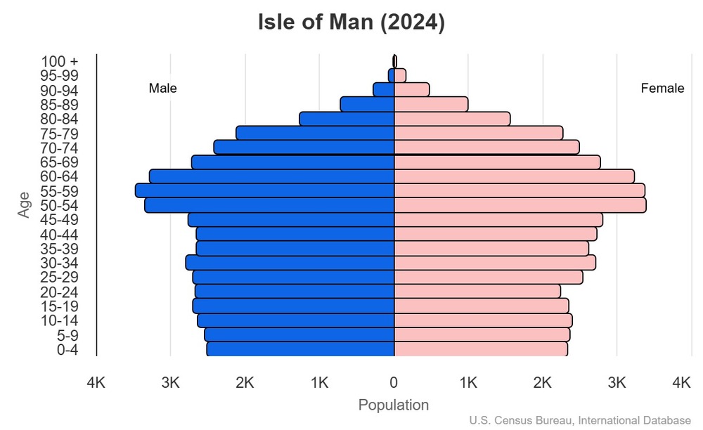
This is the population pyramid for the Isle of Man. A population pyramid illustrates the age and sex structure of a country's population and may provide insights about political and social stability, as well as economic development. The population is distributed along the horizontal axis, with males shown on the left and females on the right. The male and female populations are broken down into 5-year age groups represented as horizontal bars along the vertical axis, with the youngest age groups at the bottom and the oldest at the top. The shape of the population pyramid gradually evolves over time based on fertility, mortality, and international migration trends.
For additional information, please see the entry for Population pyramid on the Definitions and Notes page.
For additional information, please see the entry for Population pyramid on the Definitions and Notes page.
Geographic coordinates
54 15 N, 4 30 W
Sex ratio
at birth: 1.08 male(s)/female
0-14 years: 1.08 male(s)/female
15-64 years: 1.04 male(s)/female
65 years and over: 0.89 male(s)/female
total population: 1.01 male(s)/female (2024 est.)
0-14 years: 1.08 male(s)/female
15-64 years: 1.04 male(s)/female
65 years and over: 0.89 male(s)/female
total population: 1.01 male(s)/female (2024 est.)
Natural hazards
occasional high winds and rough seas
Area - comparative
slightly more than three times the size of Washington, D.C.
Background
The Isle of Man was part of the Norwegian Kingdom of the Hebrides until the 13th century, when it was ceded to Scotland. The isle came under English lordship in the 14th century before being purchased by the British Government in 1765. Current concerns include reviving the almost extinct Manx Gaelic language. The Isle of Man is a British Crown dependency, which makes it a self-governing possession of the British Crown that is not part of the UK. The UK Government, however, remains constitutionally responsible for its defense and international representation.
Environmental issues
air pollution, marine pollution; waste disposal (both household and industrial)
Exports - commodities
crude petroleum, artwork, vegetables, fruits, whiskies (2022)
note: top five export commodities based on value in dollars
note: top five export commodities based on value in dollars
Administrative divisions
no first-order administrative divisions as defined by the US government, but 24 local authorities each hold elections
Agricultural products
cereals, vegetables; cattle, sheep, pigs, poultry
Capital
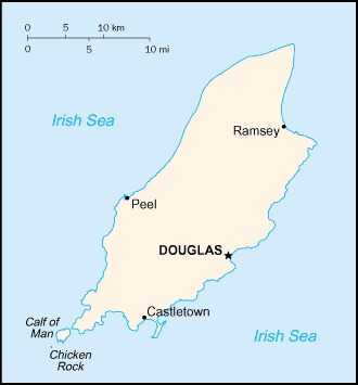
name: Douglas
geographic coordinates: 54 09 N, 4 29 W
time difference: UTC 0 (5 hours ahead of Washington, DC, during Standard Time)
daylight saving time: +1hr, begins last Sunday in March; ends last Sunday in October
etymology: the name comes from the Gaelic name Dubhghlais, or "black stream," referring to a nearby river; a second river was called Fionnghlais, or "white stream;" both river names were later shortened to Dhoo and Glass, respectively, which coincidentally comprised the elements of the town's name
Imports - commodities
ships, delivery trucks (2022)
Climate
temperate; cool summers and mild winters; overcast about a third of the time
Coastline
160 km
Constitution
history: development of the Isle of Man constitution dates to at least the 14th century
amendment process: proposed as a bill in the House of Keys, by the "Government," by a "Member of the House," or through petition to the House or Legislative Council; passage normally requires three separate readings and approval of at least 13 House members; following both House and Council agreement, assent is required by the lieutenant governor on behalf of the Crown
amendment process: proposed as a bill in the House of Keys, by the "Government," by a "Member of the House," or through petition to the House or Legislative Council; passage normally requires three separate readings and approval of at least 13 House members; following both House and Council agreement, assent is required by the lieutenant governor on behalf of the Crown
Exchange rates
Manx pounds (IMP) per US dollar -
Exchange rates:
0.782 (2024 est.)
0.805 (2023 est.)
0.811 (2022 est.)
0.727 (2021 est.)
0.78 (2020 est.)
Exchange rates:
0.782 (2024 est.)
0.805 (2023 est.)
0.811 (2022 est.)
0.727 (2021 est.)
0.78 (2020 est.)
Executive branch
chief of state: Lord of Mann King CHARLES III (since 8 September 2022); represented by Lieutenant Governor Sir John LORIMER (since 29 September 2021)
head of government: Chief Minister Alfred CANNAN (since 12 October 2021)
cabinet: Council of Ministers appointed by the lieutenant governor
election/appointment process: the monarchy is hereditary; lieutenant governor appointed by the monarch; chief minister indirectly elected by the Tynwald for a 5-year term (eligible for second term)
most recent election date: 23 September 2021
election results:
2021: Alfred CANNAN (independent) elected chief minister; Tynwald House of Keys vote - 21 of 24
2016: Howard QUAYLE elected chief minister; Tynwald House of Keys vote - 21 of 33
expected date of next election: 2026
Flag
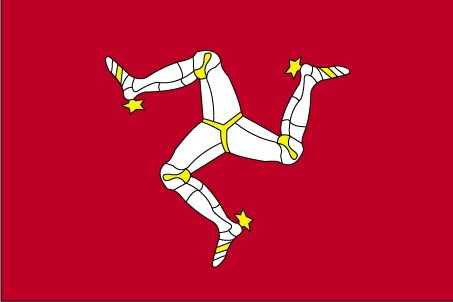
description: red with the Three Legs of Man emblem (triskelion) in the center; the three legs are joined at the thigh and bent at the knee; a two-sided emblem is used to allow the toes to point clockwise on both sides of the flag
history: the flag is based on the coat of arms of the last recognized Norse King of Mann, MAGNUS III (r. 1252-65); the triskelion has its roots in an early Celtic sun symbol
history: the flag is based on the coat of arms of the last recognized Norse King of Mann, MAGNUS III (r. 1252-65); the triskelion has its roots in an early Celtic sun symbol
Independence
none (British Crown dependency)
Industries
financial services, light manufacturing, tourism
Judicial branch
highest court(s): Isle of Man High Court of Justice (consists of 3 permanent judges or "deemsters" and 1 judge of appeal; organized into the Staff of Government Division or Court of Appeal and the Civil Division); the Court of General Gaol Delivery (not formally part of the High Court but is administered as such) deals with serious criminal cases
judge selection and term of office: deemsters appointed by the Lord Chancellor of England on the nomination of the lieutenant governor; deemsters can serve until age 70
subordinate courts: High Court; Court of Summary Gaol Delivery; Summary Courts; Magistrate's Court; specialized courts
note: appeals beyond the Court of Appeal are referred to the Judicial Committee of the Privy Council (in London)
Land boundaries
total: 0 km
Land use
agricultural land: 69.1% (2023 est.)
arable land: 41.1% (2023 est.)
permanent crops: 0% (2022 est.)
permanent pasture: 28% (2023 est.)
forest: 6.4% (2023 est.)
other: 24.5% (2023 est.)
arable land: 41.1% (2023 est.)
permanent crops: 0% (2022 est.)
permanent pasture: 28% (2023 est.)
forest: 6.4% (2023 est.)
other: 24.5% (2023 est.)
Legal system
UK laws apply, as well as Manx statutes
Legislative branch
legislature name: Tynwald (High Court of Tynwald)
legislative structure: bicameral
note: Legislative Council includes the President of Tynwald, 2 non-voting members (the Lord Bishop of Sodor and Man and the attorney general), and 8 members indirectly elected by the House of Keys
legislative structure: bicameral
note: Legislative Council includes the President of Tynwald, 2 non-voting members (the Lord Bishop of Sodor and Man and the attorney general), and 8 members indirectly elected by the House of Keys
Maritime claims
territorial sea: 12 nm
exclusive fishing zone: 12 nm
exclusive fishing zone: 12 nm
International organization participation
UPU
National holiday
Tynwald Day, 5 July (1417); date Tynwald Day was first recorded
Nationality
noun: Manxman (men), Manxwoman (women)
adjective: Manx
adjective: Manx
Natural resources
none
Geography - note
one small islet, the Calf of Man, lies to the southwest and is a bird sanctuary
Economic overview
high-income British island economy; known financial services and tourism industries; taxation incentives for technology and financial firms to operate; historic fishing and agriculture industries are declining; major online gambling and film industry locale
Political parties
Green Party
Liberal Vannin Party or LVP
Manx Labor Party
Mec Vannin (sometimes referred to as the Manx Nationalist Party)
note: most members sit as independents
Liberal Vannin Party or LVP
Manx Labor Party
Mec Vannin (sometimes referred to as the Manx Nationalist Party)
note: most members sit as independents
Railways
total: 63 km (2008)
narrow gauge: 6 km (2008) 1.076-m gauge (6 km electrified)
57 0.914-mm gauge (29 km electrified) note: primarily summer tourist attractions
narrow gauge: 6 km (2008) 1.076-m gauge (6 km electrified)
57 0.914-mm gauge (29 km electrified) note: primarily summer tourist attractions
Suffrage
16 years of age; universal
Terrain
hills in north and south bisected by central valley
Government type
parliamentary democracy (Tynwald)
Military - note
defense is the responsibility of the UK
Country name
conventional long form: none
conventional short form: Isle of Man
local long form: Ellan Vannin
abbreviation: I.O.M.
etymology: the name "man" may be derived from the Gaelic word for "mountain;" the local name is from the words ellan, or "island," and Vannin, a form of the name Mannan
conventional short form: Isle of Man
local long form: Ellan Vannin
abbreviation: I.O.M.
etymology: the name "man" may be derived from the Gaelic word for "mountain;" the local name is from the words ellan, or "island," and Vannin, a form of the name Mannan
Location
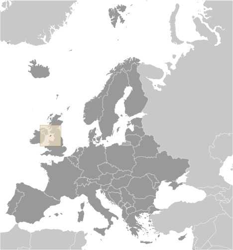
Western Europe, island in the Irish Sea, between Great Britain and Ireland
Map references
Europe
Irrigated land
0 sq km (2022)
Diplomatic representation in the US
none (British crown dependency)
Internet country code
.im
GDP (official exchange rate)
$7.431 billion (2022 est.)
note: data in current dollars at official exchange rate
note: data in current dollars at official exchange rate
Urbanization
urban population: 53.5% of total population (2023)
rate of urbanization: 0.97% annual rate of change (2020-25 est.)
rate of urbanization: 0.97% annual rate of change (2020-25 est.)
Broadcast media
national public radio has 3 FM stations and 1 AM station; 2 commercial radio broadcasters; receives radio and TV services via relays from British TV and radio broadcasters
National anthem(s)
title: "Arrane Ashoonagh dy Vannin" (Isle of Man National Anthem)
lyrics/music: William Henry GILL [English], John J. KNEEN [Manx]/traditional
history: adopted 2003; serves as a local anthem
_____
title: "God Save the King"
lyrics/music: unknown
history: official anthem, as a British Crown dependency; played when the sovereign, members of the royal family, or the lieutenant governor are present
Major urban areas - population
27,000 DOUGLAS (capital) (2018)
National symbol(s)
triskelion (a motif of three legs)
Population distribution
most people concentrated in cities and large towns; Douglas, in the southeast, is the largest
Electricity access
electrification - total population: 100% (2022 est.)
Civil aircraft registration country code prefix
M
Ethnic groups
White 94.7%, Asian 3.1%, Mixed 1%, Black 0.6%, other 0.4% (2021 est.)
note: data represent population by nationality
note: data represent population by nationality
Religions
Christian 54.7%, Muslim 0.5%, Buddhist 0.5%, Hindu 0.4%, Jewish 0.2%, none 43.8% (2021 est.)
Languages
English, Manx Gaelic (about 2% of the population has some knowledge)
Elevation
highest point: Snaefell 621 m
lowest point: Irish Sea 0 m
lowest point: Irish Sea 0 m
Dependency ratios
total dependency ratio: 61.7 (2024 est.)
youth dependency ratio: 25.9 (2024 est.)
elderly dependency ratio: 35.7 (2024 est.)
potential support ratio: 2.8 (2024 est.)
youth dependency ratio: 25.9 (2024 est.)
elderly dependency ratio: 35.7 (2024 est.)
potential support ratio: 2.8 (2024 est.)
Drinking water source
improved:
total: 99.9% of population (2022 est.)
unimproved:
total: 0.1% of population (2022 est.)
total: 99.9% of population (2022 est.)
unimproved:
total: 0.1% of population (2022 est.)
Sanitation facility access
improved:
total: 100% of population (2022 est.)
unimproved:
urban: NA
rural: NA
total: 0% of population (2022 est.) NA
total: 100% of population (2022 est.)
unimproved:
urban: NA
rural: NA
total: 0% of population (2022 est.) NA
Imports - partners
almost entirely United Kingdom (2022)
Waste and recycling
municipal solid waste generated annually: 50,600 tons (2024 est.)
percent of municipal solid waste recycled: 50% (2011 est.)
percent of municipal solid waste recycled: 50% (2011 est.)
Exports - partners
almost entirely United Kingdom (2022)
Ports
total ports: 2 (2024)
large: 0
medium: 0
small: 2
very small: 0
ports with oil terminals: 1
key ports: Douglas, Ramsey
large: 0
medium: 0
small: 2
very small: 0
ports with oil terminals: 1
key ports: Douglas, Ramsey
Legislative branch - lower chamber
chamber name: House of Keys
number of seats: 24 (directly elected)
electoral system: plurality/majority
scope of elections: full renewal
term in office: 5 years
most recent election date: 9/23/2021
parties elected and seats per party: independent (21); Manx Labour Party (2); Liberal Vannin (1)
percentage of women in chamber: 40%
expected date of next election: September 2026
Legislative branch - upper chamber
chamber name: Legislative Council
number of seats: 11 (3 appointed, 8 indirectly elected)
scope of elections: partial renewal
term in office: 4 years
most recent election date: 3/14/2023
percentage of women in chamber: 36.4%
expected date of next election: March 2028
number of seats: 11 (3 appointed, 8 indirectly elected)
scope of elections: partial renewal
term in office: 4 years
most recent election date: 3/14/2023
percentage of women in chamber: 36.4%
expected date of next election: March 2028
National color(s)
red, white
National coat of arms
Queen Elizabeth II of the United Kingdom granted the Isle of Man’s coat of arms on July 12, 1996; the triskelion (three conjoined legs) on the shield represents resilience, resourcefulness, and hope; the Latin motto means “Wherever you throw it, it will stand,” a reference to the islanders’ ability to stand strong; the peregrine falcon represents the two falcons that the Isle of Man has paid to the UK monarch on Coronation Day since 1406, and the raven symbolizes the island’s former status as a Viking colony; the crown represents the UK monarch’s status as the Lord of Mann, although the island is self-governing
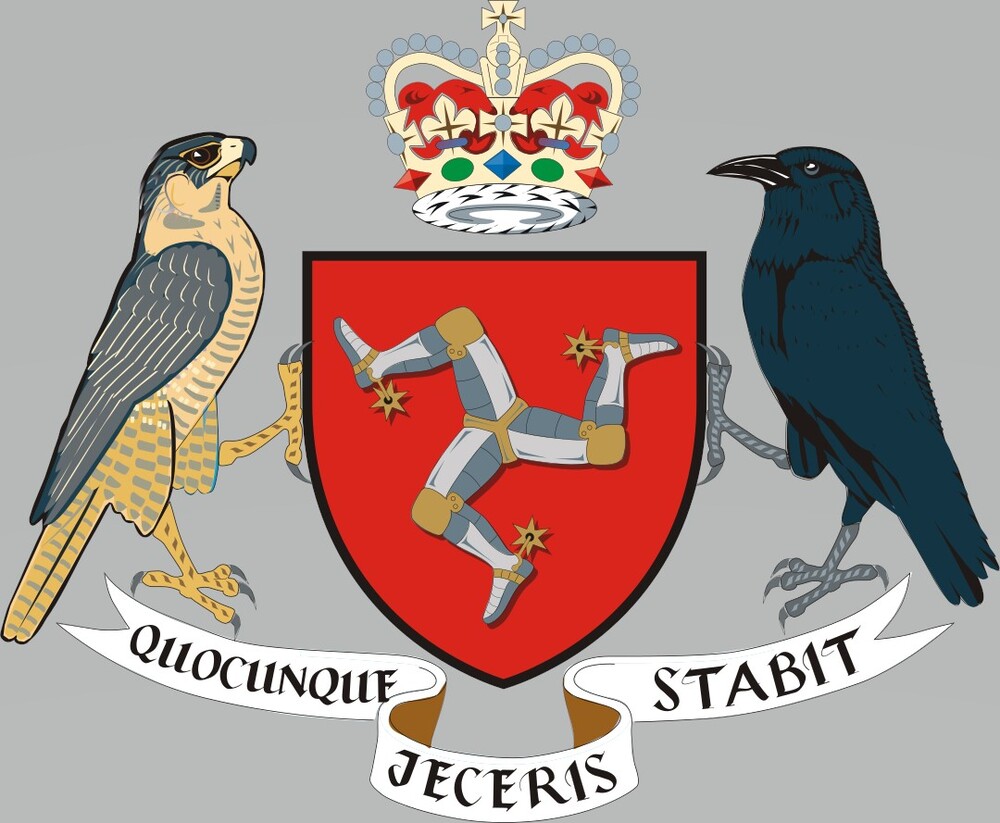
Queen Elizabeth II of the United Kingdom granted the Isle of Man’s coat of arms on July 12, 1996. The triskelion (three conjoined legs) on the shield represents resilience, resourcefulness, and hope. The Latin motto means “Wherever you throw it, it will stand,” a reference to the islanders’ ability to stand strong. The peregrine falcon represents the two falcons that the Isle of Man has paid to the UK monarch on Coronation Day since 1406, and the raven symbolizes the island’s former status as a Viking colony. The crown represents the UK monarch’s status as the Lord of Mann, although the island is self-governing.
Population
total: 92,269 (2024 est.)
male: 46,331
female: 45,938
male: 46,331
female: 45,938
Area
total : 572 sq km
land: 572 sq km
water: 0 sq km
land: 572 sq km
water: 0 sq km
Airports
4 (2025)
Merchant marine
total: 269 (2023)
by type: bulk carrier 102, container ship 6, general cargo 27, oil tanker 56, other 78
by type: bulk carrier 102, container ship 6, general cargo 27, oil tanker 56, other 78
Heliports
1 (2025)
Life expectancy at birth
total population: 82.5 years (2024 est.)
male: 80.7 years
female: 84.4 years
male: 80.7 years
female: 84.4 years
Real GDP growth rate
-4.2% (2022 est.)
3.8% (2021 est.)
-8.8% (2020 est.)
note: annual GDP % growth based on constant local currency
3.8% (2021 est.)
-8.8% (2020 est.)
note: annual GDP % growth based on constant local currency
Industrial production growth rate
-29.5% (2022 est.)
note: annual % change in industrial value added based on constant local currency
note: annual % change in industrial value added based on constant local currency
GDP - composition, by sector of origin
agriculture: 0.4% (2022 est.)
industry: 6.9% (2022 est.)
services: 95.1% (2022 est.)
note: figures may not total 100% due to non-allocated consumption not captured in sector-reported data
industry: 6.9% (2022 est.)
services: 95.1% (2022 est.)
note: figures may not total 100% due to non-allocated consumption not captured in sector-reported data
Gross reproduction rate
0.9 (2025 est.)
Net migration rate
4.06 migrant(s)/1,000 population (2025 est.)
Median age
total: 45.1 years (2025 est.)
male: 43.7 years
female: 46.1 years
male: 43.7 years
female: 46.1 years
Total fertility rate
1.87 children born/woman (2025 est.)
Infant mortality rate
total: 4 deaths/1,000 live births (2025 est.)
male: 4.4 deaths/1,000 live births
female: 3.7 deaths/1,000 live births
male: 4.4 deaths/1,000 live births
female: 3.7 deaths/1,000 live births
Death rate
10.2 deaths/1,000 population (2025 est.)
Birth rate
10.25 births/1,000 population (2025 est.)
Population growth rate
0.41% (2025 est.)