Greenland - GL - GRL - North America
Last updated: January 05, 2026
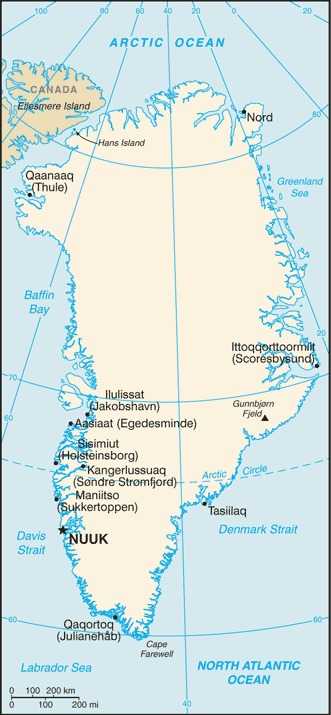
Greenland Images
Greenland Factbook Data
Dependency status
part of the Kingdom of Denmark; self-governing overseas administrative division of Denmark since 1979
Diplomatic representation from the US
chief of mission: Consul Susan A. "Suzi" WILSON (since August 2025)
embassy: Aalisartut Aqqutaa 47
Nuuk 3900
Greenland
telephone: (+299) 384100
email address and website:
USConsulateNuuk@state.gov
Homepage - U.S. Embassy & Consulate in the Kingdom of Denmark (usembassy.gov)
embassy: Aalisartut Aqqutaa 47
Nuuk 3900
Greenland
telephone: (+299) 384100
email address and website:
USConsulateNuuk@state.gov
Homepage - U.S. Embassy & Consulate in the Kingdom of Denmark (usembassy.gov)
Age structure
0-14 years: 20.4% (male 5,964/female 5,798)
15-64 years: 67.1% (male 20,050/female 18,711)
65 years and over: 12.5% (2024 est.) (male 3,829/female 3,399)
15-64 years: 67.1% (male 20,050/female 18,711)
65 years and over: 12.5% (2024 est.) (male 3,829/female 3,399)
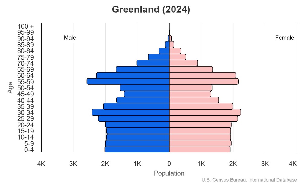
This is the population pyramid for Greenland. A population pyramid illustrates the age and sex structure of a country's population and may provide insights about political and social stability, as well as economic development. The population is distributed along the horizontal axis, with males shown on the left and females on the right. The male and female populations are broken down into 5-year age groups represented as horizontal bars along the vertical axis, with the youngest age groups at the bottom and the oldest at the top. The shape of the population pyramid gradually evolves over time based on fertility, mortality, and international migration trends.
For additional information, please see the entry for Population pyramid on the Definitions and Notes page.
For additional information, please see the entry for Population pyramid on the Definitions and Notes page.
Geographic coordinates
72 00 N, 40 00 W
Sex ratio
at birth: 1.05 male(s)/female
0-14 years: 1.03 male(s)/female
15-64 years: 1.07 male(s)/female
65 years and over: 1.13 male(s)/female
total population: 1.07 male(s)/female (2024 est.)
0-14 years: 1.03 male(s)/female
15-64 years: 1.07 male(s)/female
65 years and over: 1.13 male(s)/female
total population: 1.07 male(s)/female (2024 est.)
Natural hazards
continuous permafrost over northern two-thirds of the island
Area - comparative
slightly more than three times the size of Texas
Background
Greenland, the world's largest island, is about 80% ice capped. The Inuit came to Greenland from North America in a series of migrations that stretched from 2500 BC to the11th century. Vikings reached the island in the 10th century from Iceland; Danish colonization began in the 18th century, and Greenland became part of the Kingdom of Denmark in 1953. It joined the European Community (now the EU) with Denmark in 1973 but withdrew in 1985 over a dispute centered on stringent fishing quotas. Greenland remains a member of the EU's Overseas Countries and Territories Association. The Danish parliament granted Greenland home rule in 1979; the law went into effect the following year. Greenland voted in favor of self-government in 2008 and acquired greater responsibility for internal affairs when the Act on Greenland Self-Government was signed into law in 2009. The Kingdom of Denmark, however, continues to exercise control over several policy areas on behalf of Greenland, including foreign affairs, security, and financial policy, in consultation with Greenland's Self-Rule Government.
Environmental issues
changes in sea levels and other disruptions in the Arctic environment
Exports - commodities
fish, shellfish, processed crustaceans, ships, precious stones (2023)
note: top five export commodities based on value in dollars
note: top five export commodities based on value in dollars
Exports - partners
Denmark 50%, China 23%, UK 5%, Japan 5%, Germany 3% (2023)
note: top five export partners based on percentage share of exports
note: top five export partners based on percentage share of exports
Administrative divisions
5 municipalities (kommuner, singular - kommune); Avannaata, Kujalleq, Qeqertalik, Qeqqata, Sermersooq
note: Northeast Greenland National Park (Kalaallit Nunaanni Nuna Eqqissisimatitaq) and the Pituffik Space Base (formerly known as Thule Air Base) in northwest Greenland are two unincorporated areas; the national park's 972,000 sq km -- about 46% of the island -- makes it the largest national park in the world and also the most northerly
note: Northeast Greenland National Park (Kalaallit Nunaanni Nuna Eqqissisimatitaq) and the Pituffik Space Base (formerly known as Thule Air Base) in northwest Greenland are two unincorporated areas; the national park's 972,000 sq km -- about 46% of the island -- makes it the largest national park in the world and also the most northerly
Agricultural products
sheep, cattle, reindeer, fish, shellfish
Military and security forces
no regular military forces
Budget
revenues: $1.719 billion (2016 est.)
expenditures: $1.594 billion (2016 est.)
expenditures: $1.594 billion (2016 est.)
Capital
name: Nuuk
geographic coordinates: 64 11 N, 51 45 W
time difference: UTC-2 (3 hours ahead of Washington, DC, during Standard Time)
daylight saving time: +1hr, begins last Sunday in March; ends last Sunday in October
time zone note: Greenland has three time zones
etymology: nuuk is the Inuit word for "cape;" until 1979, the name was Godthab, from the Danish words meaning "good hope"
Imports - commodities
refined petroleum, ships, garments, plastic products, furniture (2023)
note: top five import commodities based on value in dollars
note: top five import commodities based on value in dollars
Climate
arctic to subarctic; cool summers, cold winters
Coastline
44,087 km
Constitution
history: previous 1953 (Greenland established as a constituency in the Danish constitution), 1979 (Greenland Home Rule Act); latest 21 June 2009 (Greenland Self-Government Act)
Exchange rates
Danish kroner (DKK) per US dollar -
Exchange rates:
6.894 (2024 est.)
6.89 (2023 est.)
7.076 (2022 est.)
6.287 (2021 est.)
6.542 (2020 est.)
Exchange rates:
6.894 (2024 est.)
6.89 (2023 est.)
7.076 (2022 est.)
6.287 (2021 est.)
6.542 (2020 est.)
Executive branch
chief of state: King FREDERIK X of Denmark (since 14 January 2024), represented by High Commissioner Julie Praest WILCHE (since May 2022) (2024)
head of government: Prime Minister Jens-Frederik NIELSEN (since 28 March 2025)
cabinet: Self-rule Government (Naalakkersuisut) elected by the Parliament (Inatsisartut)
election/appointment process: the monarchy is hereditary; high commissioner appointed by the monarch; premier indirectly elected by Parliament for a 4-year term
election results: 2025: Jens-Frederik NIELSEN (D) elected premier
2021: Mute B. EGEDE elected premier; Parliament vote - Mute B. EGEDE (Inuit Ataqatigiit) unanimous
2014: Kim KIELSEN elected premier; Parliament vote - Kim KIELSEN (S) 27.2%, Sara OLSVIG (IA) 25.5%, Randi Vestergaard EVALDSEN (D) 19.5%, other 27.8%
Flag
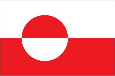
description: two equal horizontal bands of white (top) and red, with a large disk set slightly to the left; the top half of the disk is red, and the bottom is white
meaning: the design represents the sun reflecting off a field of ice; the colors are the same as the Danish flag and symbolize Greenland's links to the Kingdom of Denmark
meaning: the design represents the sun reflecting off a field of ice; the colors are the same as the Danish flag and symbolize Greenland's links to the Kingdom of Denmark
Independence
none (extensive self-rule as part of the Kingdom of Denmark)
Industries
fish processing (mainly shrimp and Greenland halibut), anorthosite and ruby mining, handicrafts, hides and skins, small shipyards
Judicial branch
highest court(s): High Court of Greenland (consists of the presiding professional judge and 2 lay assessors)
judge selection and term of office: judges appointed by the monarch on the recommendation of the Judicial Appointments Council, a 6-member independent body of judges and lawyers; judges appointed for life with retirement at age 70
subordinate courts: Court of Greenland; 18 district or magistrates' courts
note: appeals beyond the High Court of Greenland can be heard by the Supreme Court (in Copenhagen)
Land boundaries
total: 0 km
Land use
agricultural land: 0.6% (2023 est.)
arable land: 0% (2022 est.)
permanent crops: 0% (2022 est.)
permanent pasture: 0.6% (2023 est.)
forest: 0% (2023 est.)
other: 99.4% (2023 est.)
arable land: 0% (2022 est.)
permanent crops: 0% (2022 est.)
permanent pasture: 0.6% (2023 est.)
forest: 0% (2023 est.)
other: 99.4% (2023 est.)
Legal system
Denmark's laws apply in some areas, and Greenland's law for the remainder
Legislative branch
legislature name: Parliament (Inatsisartut)
legislative structure: unicameral
number of seats: 31 (directly elected)
electoral system: proportional representation
scope of elections: full renewal
term in office: 4 years
most recent election date: 4/6/2021
parties elected and seats per party: IA (12); S (10); N (4); D (3); A (2)
percentage of women in chamber: 35%
expected date of next election: 2025
note: Greenland elects 2 members to the Danish Parliament to serve 4-year terms
Maritime claims
territorial sea: 3 nm
continental shelf: 200 nm or agreed boundaries or median line
exclusive fishing zone: 200 nm or agreed boundaries or median line
continental shelf: 200 nm or agreed boundaries or median line
exclusive fishing zone: 200 nm or agreed boundaries or median line
International organization participation
Arctic Council, ICC, NC, NIB, UPU
National holiday
National Day, June 21
note: marks the summer solstice and the longest day of the year in the Northern Hemisphere
note: marks the summer solstice and the longest day of the year in the Northern Hemisphere
Nationality
noun: Greenlander(s)
adjective: Greenlandic
adjective: Greenlandic
Natural resources
coal, iron ore, lead, zinc, molybdenum, diamonds, gold, platinum, niobium, tantalite, uranium, fish, seals, whales, hydropower, possible oil and gas
Geography - note
dominates North Atlantic Ocean between North America and Europe; sparse population confined to small settlements along coast; close to one-quarter of the population lives in the capital, Nuuk; world's second largest ice sheet after that of Antarctica, covering an area of 1.71 million sq km (660,000 sq mi), or about 79% of the island, and containing 2.85 million cu km (684 thousand cu mi) of ice (almost 7% of the world's fresh water)
Economic overview
high-income, self-governing Danish territorial economy; non-EU member but preferential market access; dependent on Danish financial support; exports led by fishing industry; growing tourism and interest in untapped mineral deposits; relies on hydropower for fuel
Political parties
Democrats Party (Demokraatit) or D
Fellowship Party (Atassut) or A
Forward Party (Siumut) or S
Inuit Community (Inuit Ataqatigiit) or IA
Signpost Party (Naleraq) or N (formerly Partii Naleraq)
Fellowship Party (Atassut) or A
Forward Party (Siumut) or S
Inuit Community (Inuit Ataqatigiit) or IA
Signpost Party (Naleraq) or N (formerly Partii Naleraq)
Suffrage
18 years of age; universal
Terrain
flat to gradually sloping icecap covers all but a narrow, mountainous, barren, rocky coast
Government type
parliamentary democracy (Parliament of Greenland or Inatsisartut)
Military - note
the Danish military’s Joint Arctic Command in Nuuk is responsible for coordinating Denmark's defense of Greenland
the US Space Force maintains a base on Greenland’s northwest coast, about 750 miles from the North Pole
the US Space Force maintains a base on Greenland’s northwest coast, about 750 miles from the North Pole
Country name
conventional long form: none
conventional short form: Greenland
local long form: none
local short form: Kalaallit Nunaat
etymology: named by Norse navigator Erik THORVALDSSON (Erik the Red) in A.D. 985 to attract settlers to the island; the original Greenlandic name, Kalaallit Nunaat, means "land of the people"
conventional short form: Greenland
local long form: none
local short form: Kalaallit Nunaat
etymology: named by Norse navigator Erik THORVALDSSON (Erik the Red) in A.D. 985 to attract settlers to the island; the original Greenlandic name, Kalaallit Nunaat, means "land of the people"
Location
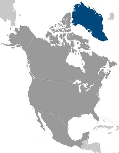
Northern North America, island between the Arctic Ocean and the North Atlantic Ocean, northeast of Canada
Map references
Arctic Region
Irrigated land
NA
Diplomatic representation in the US
chief of mission: Kenneth HØEGH, Head of Representation (since 1 August 2021)
chancery: 3200 Whitehaven Street, NW
Washington, DC 20008
telephone: [1] (202) 234-4300
FAX: [1] (202) 328-1470
email address and website:
washington@nanoq.gl
All Greenlandic Representations | Grønlands Repræsentation (grl-rep.dk);
https://naalakkersuisut.gl/en/Naalakkersuisut/Groenlands-repraesentation-Washington
note: Greenland also has offices in the Danish consulates in Chicago and New York
Internet users
percent of population: 70% (2017 est.)
Internet country code
.gl
GDP (official exchange rate)
$3.327 billion (2023 est.)
note: data in current dollars at official exchange rate
note: data in current dollars at official exchange rate
Urbanization
urban population: 87.9% of total population (2023)
rate of urbanization: 0.41% annual rate of change (2020-25 est.)
rate of urbanization: 0.41% annual rate of change (2020-25 est.)
Broadcast media
Greenland Broadcasting Company provides public radio and TV, with a broadcast station and a series of repeaters; a few private local TV and radio stations; Danish public radio rebroadcasts are available (2019)
Drinking water source
improved:
total: 100% of population (2022 est.)
unimproved:
total: 0% of population (2022 est.)
total: 100% of population (2022 est.)
unimproved:
total: 0% of population (2022 est.)
National anthem(s)
title: "Nunarput utoqqarsuanngoravit" (Our Country, Who's Become So Old)
lyrics/music: Henrik LUND/Jonathan PETERSEN
history: adopted 1916
_____
title: "Nuna asiilasooq" (The Land of Great Length)
lyrics/music: unknown
history: adopted 1979, when home rule was granted; the Greenlandic government recognizes this local Kalaallit song as a secondary anthem
lyrics/music: Henrik LUND/Jonathan PETERSEN
history: adopted 1916
_____
title: "Nuna asiilasooq" (The Land of Great Length)
lyrics/music: unknown
history: adopted 1979, when home rule was granted; the Greenlandic government recognizes this local Kalaallit song as a secondary anthem
Major urban areas - population
18,000 NUUK (capital) (2018)
Physician density
1.87 physicians/1,000 population (2016)
National symbol(s)
polar bear
GDP - composition, by end use
household consumption: 32.6% (2023 est.)
government consumption: 41.7% (2023 est.)
investment in fixed capital: 34.7% (2023 est.)
investment in inventories: 1.3% (2023 est.)
exports of goods and services: 40.8% (2023 est.)
imports of goods and services: -51.1% (2023 est.)
note: figures may not total 100% due to rounding or gaps in data collection
Population distribution
settlement concentrated on the southwest shoreline, with limited settlements scattered along the remaining coast; interior is uninhabited
Electricity access
electrification - total population: 100% (2022 est.)
Civil aircraft registration country code prefix
OY-H
Sanitation facility access
improved:
total: 62.5% of population (2022 est.)
unimproved:
urban: 0% of population
rural: 0% of population
total: 37.5% of population (2022 est.)
total: 62.5% of population (2022 est.)
unimproved:
urban: 0% of population
rural: 0% of population
total: 37.5% of population (2022 est.)
Ethnic groups
Greenlandic 88.1%, Danish 7.1%, Filipino 1.6%, other Nordic peoples 0.9%, and other 2.3% (2024 est.)
note: data represent population by country of birth
note: data represent population by country of birth
Religions
Evangelical Lutheran, traditional Inuit spiritual beliefs
Languages
Greenlandic, Danish, English
note: West Greenlandic or Kalaallisut is the official language; Tunumiisut (East Greenlandic) and Inuktun (Polar Inuit Greenlandic) are considered dialects of Kalaallisut and spoken by about 10% of Greenlanders
note: West Greenlandic or Kalaallisut is the official language; Tunumiisut (East Greenlandic) and Inuktun (Polar Inuit Greenlandic) are considered dialects of Kalaallisut and spoken by about 10% of Greenlanders
Imports - partners
Denmark 58%, Sweden 19%, Spain 8%, Iceland 7%, Canada 2% (2023)
note: top five import partners based on percentage share of imports
note: top five import partners based on percentage share of imports
Elevation
highest point: Gunnbjorn Fjeld 3,694 m
lowest point: Atlantic Ocean 0 m
mean elevation: 1,792 m
lowest point: Atlantic Ocean 0 m
mean elevation: 1,792 m
Dependency ratios
total dependency ratio: 49 (2024 est.)
youth dependency ratio: 30.3 (2024 est.)
elderly dependency ratio: 18.6 (2024 est.)
potential support ratio: 5.4 (2024 est.)
youth dependency ratio: 30.3 (2024 est.)
elderly dependency ratio: 18.6 (2024 est.)
potential support ratio: 5.4 (2024 est.)
Waste and recycling
municipal solid waste generated annually: 50,000 tons (2024 est.)
National heritage
total World Heritage Sites: 3 (2 cultural, 1 natural); note - excerpted from the Denmark entry
selected World Heritage Site locales: Ilulissat Icefjord (n); Kujataa, Norse, and Inuit Farming (c); Aasivissuit–Nipisat, Inuit Hunting Ground (c)
selected World Heritage Site locales: Ilulissat Icefjord (n); Kujataa, Norse, and Inuit Farming (c); Aasivissuit–Nipisat, Inuit Hunting Ground (c)
Coal
imports: 5 metric tons (2023 est.)
proven reserves: 383 million metric tons (2023 est.)
proven reserves: 383 million metric tons (2023 est.)
Electricity generation sources
fossil fuels: 13.6% of total installed capacity (2023 est.)
solar: 0.2% of total installed capacity (2023 est.)
hydroelectricity: 85.8% of total installed capacity (2023 est.)
biomass and waste: 0.5% of total installed capacity (2023 est.)
solar: 0.2% of total installed capacity (2023 est.)
hydroelectricity: 85.8% of total installed capacity (2023 est.)
biomass and waste: 0.5% of total installed capacity (2023 est.)
Petroleum
refined petroleum consumption: 4,000 bbl/day (2023 est.)
Currently married women (ages 15-49)
38.8% (2022 est.)
Ports
total ports: 23 (2024)
large: 0
medium: 0
small: 7
very small: 10
size unknown: 6
ports with oil terminals: 5
key ports: Aasiaat, Illulissat (Jakobshavn), Kusanartoq, Nuuk, Paamuit (Frederikshab), Qeqertarsuaq, Sisimiut
large: 0
medium: 0
small: 7
very small: 10
size unknown: 6
ports with oil terminals: 5
key ports: Aasiaat, Illulissat (Jakobshavn), Kusanartoq, Nuuk, Paamuit (Frederikshab), Qeqertarsuaq, Sisimiut
National color(s)
red, white
Population
total: 57,751 (2024 est.)
male: 29,843
female: 27,908
male: 29,843
female: 27,908
Carbon dioxide emissions
527,000 metric tonnes of CO2 (2023 est.)
from coal and metallurgical coke: 12 metric tonnes of CO2 (2023 est.)
from petroleum and other liquids: 527,000 metric tonnes of CO2 (2023 est.)
from coal and metallurgical coke: 12 metric tonnes of CO2 (2023 est.)
from petroleum and other liquids: 527,000 metric tonnes of CO2 (2023 est.)
Area
total : 2,166,086 sq km
land: 2,166,086 sq km (approximately 1,710,000 sq km ice-covered)
land: 2,166,086 sq km (approximately 1,710,000 sq km ice-covered)
Real GDP (purchasing power parity)
$4.04 billion (2023 est.)
$4.005 billion (2022 est.)
$3.926 billion (2021 est.)
note: data in 2021 dollars
$4.005 billion (2022 est.)
$3.926 billion (2021 est.)
note: data in 2021 dollars
Airports
25 (2025)
Telephones - mobile cellular
total subscriptions: 67,000 (2021 est.)
subscriptions per 100 inhabitants: 118 (2021 est.)
subscriptions per 100 inhabitants: 118 (2021 est.)
Inflation rate (consumer prices)
1.2% (2022 est.)
0% (2021 est.)
2.1% (2020 est.)
note: annual % change based on consumer prices
0% (2021 est.)
2.1% (2020 est.)
note: annual % change based on consumer prices
Real GDP per capita
$71,000 (2023 est.)
$70,700 (2022 est.)
$69,300 (2021 est.)
note: data in 2021 dollars
$70,700 (2022 est.)
$69,300 (2021 est.)
note: data in 2021 dollars
Broadband - fixed subscriptions
total: 18,000 (2022 est.)
subscriptions per 100 inhabitants: 32 (2022 est.)
subscriptions per 100 inhabitants: 32 (2022 est.)
Electricity
installed generating capacity: 190,000 kW (2023 est.)
consumption: 534.5 million kWh (2023 est.)
transmission/distribution losses: 10 million kWh (2023 est.)
consumption: 534.5 million kWh (2023 est.)
transmission/distribution losses: 10 million kWh (2023 est.)
Merchant marine
total: 10 (2023)
by type: other 10
by type: other 10
Imports
$1.7 billion (2023 est.)
$1.657 billion (2022 est.)
$1.635 billion (2021 est.)
note: GDP expenditure basis - imports of goods and services in current dollars
$1.657 billion (2022 est.)
$1.635 billion (2021 est.)
note: GDP expenditure basis - imports of goods and services in current dollars
Exports
$1.357 billion (2023 est.)
$1.286 billion (2022 est.)
$1.122 billion (2021 est.)
note: GDP expenditure basis - exports of goods and services in current dollars
$1.286 billion (2022 est.)
$1.122 billion (2021 est.)
note: GDP expenditure basis - exports of goods and services in current dollars
Heliports
54 (2025)
Telephones - fixed lines
total subscriptions: 6,000 (2020 est.)
subscriptions per 100 inhabitants: 9 (2022 est.)
subscriptions per 100 inhabitants: 9 (2022 est.)
Life expectancy at birth
total population: 74.5 years (2024 est.)
male: 71.8 years
female: 77.3 years
male: 71.8 years
female: 77.3 years
Real GDP growth rate
0.9% (2023 est.)
2% (2022 est.)
1.6% (2021 est.)
note: annual GDP % growth based on constant local currency
2% (2022 est.)
1.6% (2021 est.)
note: annual GDP % growth based on constant local currency
Industrial production growth rate
-1.3% (2023 est.)
note: annual % change in industrial value added based on constant local currency
note: annual % change in industrial value added based on constant local currency
GDP - composition, by sector of origin
agriculture: 16.6% (2023 est.)
industry: 18.4% (2023 est.)
services: 61% (2023 est.)
note: figures may not total 100% due to non-allocated consumption not captured in sector-reported data
industry: 18.4% (2023 est.)
services: 61% (2023 est.)
note: figures may not total 100% due to non-allocated consumption not captured in sector-reported data
Education expenditure
10.2% of GDP (2019 est.)
Gross reproduction rate
0.91 (2025 est.)
Net migration rate
-4.82 migrant(s)/1,000 population (2025 est.)
Median age
total: 35.6 years (2025 est.)
male: 35.9 years
female: 34.7 years
male: 35.9 years
female: 34.7 years
Total fertility rate
1.87 children born/woman (2025 est.)
Infant mortality rate
total: 8.3 deaths/1,000 live births (2025 est.)
male: 9.9 deaths/1,000 live births
female: 6.9 deaths/1,000 live births
male: 9.9 deaths/1,000 live births
female: 6.9 deaths/1,000 live births
Death rate
9.29 deaths/1,000 population (2025 est.)
Birth rate
13.32 births/1,000 population (2025 est.)
Population growth rate
-0.08% (2025 est.)
